BLynn

EasyDNNNews

KGIS has switched back to the 2010 Aerials as the default Aerial map theme.

Because of problems caching the 2013 Aerial imagery KGIS has switched back to the 2010 Aerial as the default Aerial map theme. If you want to switch to the 2013 Aerial you can change map theme by clicking on the Maps tab, next click on Historical Aerials drop-down arrow to the right of the word Historical Aerials, then click on the circle to the left of 2013 Aerial. (For more info click here.)

Tuesday, January 14, 2014/Author: Jimmy Brink/Number of views (1081)/Comments (0)/ Article rating: No rating
Categories: PublicKGIS Depts

Google Maps updated with Fall 2013 Aerials for Knox

Map Update Notification

Fall 2013 aerials in Google MapsRecent Google Imagery Update Alerts received by KGIS indicate that the aerials for most of Knox County have been updated to what looks to be Fall 2013 vintage. The extents of the new photography are not quite known since it is blended / mosaiced together in a seamless fashion, but the color variations of the tree canopy are indicative of a Fall acquisition (see image to right)...Click Here for More Information.

Monday, January 13, 2014/Author: Keith G. Stump/Number of views (1398)/Comments (0)/ Article rating: No rating
Categories: Public

Updated Aerials Products coming to KGIS

Data includes Orthos, Obliques and LiDAR of entire KUB Service Area

Aerial Photography will be captured for the entire Knox County and KUB service areas during the early months of 2014 as part of a GIS information improvement project jointly supported by Knox County, KUB and the City of Knoxville. In addition to providing updates to KGIS's 2010-vintage aerial ortho-photography, the project (with EagleVision / Pictometry Inc) will provide KGIS with a new update to its 6-year-old LiDAR datasets ... (Click here for more information)

Monday, January 13, 2014/Author: Keith G. Stump/Number of views (856)/Comments (0)/ Article rating: No rating
Categories: Public

2010 Census Data in KGIS Advanced Maps

Tract Numbers and Population Labels

The Census data layers have been updated on the KGIS Advanced Maps website to display the 2010 Census Tracts and population labels. To display the Census map theme click here or click on the Maps tab left of the map, then expand the Other Maps section, next click on the Census Tracts map theme. For more information, Click Here.

Tuesday, December 3, 2013/Author: Jimmy Brink/Number of views (92)/Comments (0)/ Article rating: No rating

Google Street View Issue

Google's API change is causing problems for some browsers

Google recently updated their Google Maps Javascript API, which KGIS is using to display street view maps.  This change is  causing some older browsers to distort the street view picture.  Below are two examples:

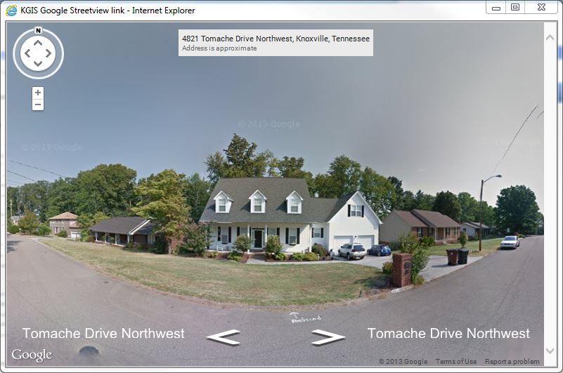
Internet Explorer - this is the view that you may see inside of most Internet Explorer (IE) browsers.  Note the "bubble" effect - this should be a straight section of road. Internet Explorer 10 and prior will definitely have this problem.  IE 11 may or may not have this issue, it seems to be behaving differently on different machines. Click the image to the left to see the full size image.
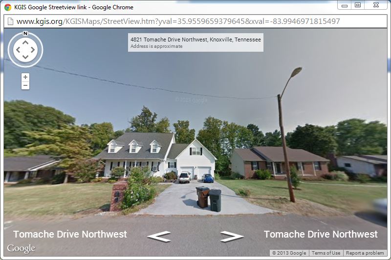
Google Chrome - the Chrome browser fully supports the Google Maps API and therefore does not have the same problems displaying the street view image. Click the image to the left to see the full size image.
Monday, December 2, 2013/Author: Bryan Lynn/Number of views (1314)/Comments (0)/ Article rating: No rating
Categories: Public
First567810121314Last

Theme picker