BLynn

EasyDNNNews

Chrome Dropping Silverlight

Google Chrome will phase out Silverlight support in 2015

Now that HTML5 has become more widely supported, Google has announced a timeline for their discontinued support for Microsoft's Silverlight plug-in.  This will take place in 3 phases over the next 9 months with support being completely removed by September 2015.  Click here to see how KGIS plans to adjust to the upcoming changes.
Monday, December 15, 2014/Author: Bryan Lynn/Number of views (161)/Comments (0)/ Article rating: No rating

KGIS has switched back to the 2010 Aerials as the default Aerial map theme.

Because of problems caching the 2013 Aerial imagery KGIS has switched back to the 2010 Aerial as the default Aerial map theme. If you want to switch to the 2013 Aerial you can change map theme by clicking on the Maps tab, next click on Historical Aerials drop-down arrow to the right of the word Historical Aerials, then click on the circle to the left of 2013 Aerial. (For more info click here.)

Tuesday, January 14, 2014/Author: Jimmy Brink/Number of views (1083)/Comments (0)/ Article rating: No rating
Categories: PublicKGIS Depts

2010 Census Data in KGIS Advanced Maps

Tract Numbers and Population Labels
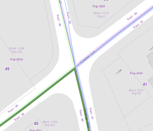
The Census data layers have been updated on the KGIS Advanced Maps website to display the 2010 Census Tracts and population labels. To display the Census map theme click here or click on the Maps tab left of the map, then expand the Other Maps section, next click on the Census Tracts map theme. For more information, Click Here.

Tuesday, December 3, 2013/Author: Jimmy Brink/Number of views (93)/Comments (0)/ Article rating: No rating

Public Land Inventory has been updated

City and County Owned Land

KGIS has recently updated its inventory list of parcels that are owned by City, County and other public institutions. This list is stored in KGIS's Oracle database, and is therefore accessible to any or our respective ESRI ArcGIS software users. However, one can also access this data via the browser-based KGIS Advanced Maps  application. ...MORE..

Friday, July 26, 2013/Author: Keith G. Stump/Number of views (117)/Comments (0)/ Article rating: No rating

CBID Grants Map added by News Sentinel

Google Maps "mashup" created by Property Scope Blog's Josh Flory

A Google Maps interactive map "mashup" of Central Business Improvement District (CBID)-approved grants has been created by the Property Scope Blog's Josh Flory. KGIS's new KGIS Advanced Maps application has some capabilities that will also allow one to "mash up" or import data and view it on the map....KGIS plans to demo this capability at one of the future Users Group meetings.

Tuesday, May 14, 2013/Author: Keith G. Stump/Number of views (96)/Comments (0)/ Article rating: No rating
Categories: Partners
12

Theme picker