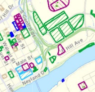
 KGIS has recently updated its inventory list of parcels that are owned by City, County and other public institutions. This list is stored in KGIS's Oracle database, and is therefore accessible to any or our respective ESRI ArcGIS software users. However, one can also access this data via the browser-based KGIS Advanced Maps application.
-------------------------------------------------------
The Oracle table name is called CAD_CountyOwnedLand_KNO. ArcGIS software users will want to "join" this table against the Parcels feature class (CAD_Parcels_KNO) in order to view them on "the map".
KGIS Advanced Maps users can access this information via one of following OPTIONS:
- Open Project button (yellow folder icon in the upper left portion of the KGIS Advanced Maps app) ...Then select "Public Land Inventory"
- Add Layer (from the Customize tab)...Then select Public Land...and step through the various Next and OK buttons.
- Click on this hyperlink (which will automatically open the Public Land Inventory project)...However, keep in mind that the hyperlink to this project file may change in the future...Option 1 will then be the manner needed in order to access the updated project file.)