BLynn

EasyDNNNews

Testing

Testing

Testing the new news module on test.kgis.org

Thursday, December 5, 2019/Author: Bryan Lynn/Number of views (142)/Comments (0)/ Article rating: No rating
Categories: Public
Tags: Whats New

QC'ing the Contours

New 2' contour data covers all of Knox and KUB areas

TESTING....KGIS has just received a delivery of the 2' contour data covering all of Knox County and the entire KUB service area. The dataset is HUGE! More than 17 gigs in size (as compared with our previous contour dataset size of 5 gigs). And the detail seems to reflect the very high accuracy of the LiDAR data that was flown at a 4 points per meter density back in the spring of 2016. READ MORE...


Monday, May 8, 2017/Author: Keith G. Stump/Number of views (149)/Comments (0)/ Article rating: No rating

City Tax Levy Link is now supported

accessed via KGIS Maps - Full Parcel Details

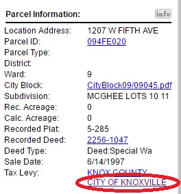
The City of Knoxville Tax Levy Link has been updated to provide quicker, easier access to City Finance's Tax Lookup website. The Tax Levy link can be accessed via the Full Parcel Details section of KGIS Maps. (see image).

Follow these steps to get to the Tax Levy Link in KGIS Maps:

  • Select a parcel via the Parcel Identify tool (located on the blue command bar) or via the Search By tool located at the top of the page.
  • Then, within the Parcel Info bubble, click on the third icon: Get Full Parcel Details 
  • Then, scroll down the Results pane to the hyperlinked text Tax Levy: "CITY OF KNOXVILLE"
Monday, March 13, 2017/Author: Anonym/Number of views (79)/Comments (0)/ Article rating: No rating

Update to the 2016 Landbase Project

Topography and Hydrography

Atlantic has asked for a delay in delivering the Phase 1 Topography and Hydrography features to KGIS. Originally due on December 16, 2016. KGIS received an updated schedule you can view it here. KGIS will receive the contour data by March 20, 2017 and the KGIS planimetric March 31, 2017. 

You can read more here.

Friday, January 13, 2017/Author: Anonym/Number of views (80)/Comments (0)/ Article rating: No rating

2016 Landbase Update Phase 1 Delayed

Topography and Hydrography

Atlantic has asked for a delay in delivering the Phase 1 Topography and Hydrography features to KGIS. Originally due on December 16, 2016, KGIS had hopes of making these features immediate available to our users in ArcMap and on the website. KGIS will get an updated schedule next week and will post an update as soon as we know. Atlantic has updated or modified almost 24,300 features and the horizontal accuracy looks really good.   

You can read more here.

Thursday, December 15, 2016/Author: Anonym/Number of views (90)/Comments (0)/ Article rating: No rating
1345678910Last

Theme picker