 KGIS has just received a delivery of the 2' contour data covering all of Knox County and the entire KUB service area. The dataset is HUGE! More than 17 gigs in size (as compared with our previous contour dataset size of 5 gigs). And the detail seems to reflect the very high accuracy of the LiDAR data that was flown at a 4 points per meter density back in the spring of 2016.
----------------------------------------------
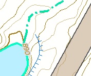
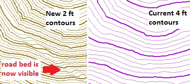
Here below is an example of the increased level of detail in an area of west Knox County, where KGIS currently has only 4' contours, but which will now be covered by 2' contours. The new data allows one to visually "see" more features of the land, even when covered by tree canopy.
However, this will NOT be the final delivery of contour data. There are several problems that will need to be corrected by Atlantic, including cartographic adjustments around bridges and readjustment of depression contours. We will also work with Atlantic to further generalize the data, reducing its data size and removing unnecessarily small contour "islands'.
Desktop users of KGIS's GIS software (ESRI ArcMap) can access the newly delivered featureclasses by connecting to KGIS's central SDE database (see list of featureclass names are below). Nevertheless, KGIS users should recognize that the data is NOT in its final form. Even though the data is much more detailed, and up-to-date, its use should therefore be restricted until it has been re-delivered to KGIS.
At a future date, KGIS plans to conduct a workshop to help orient KGIS users to the new datasets, which do have some minor differences from our current (but 9-year-old) products.
LiDAR and HILLSHADE / DEM products.
The 3-d LiDAR dataset (from which the contours are being produced) is also available to KGIS users (and sub-contractors of the City, County, KUB). By-products of this lidar data,including Hillshade and DEMs, show unsurpassed detail (compared with KGIS's previous products). The DEMs are 1ft grid resolution (as compared to KGIS's previous 5ft grid) and should therefore provide excellent data for accurate Floodplain mapping or slope modeling.
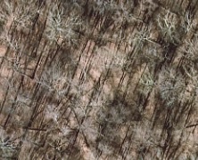
COLOR INFRARED.
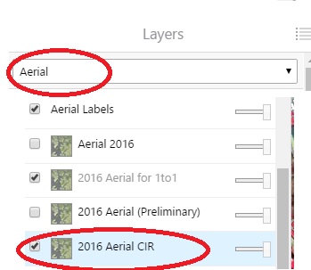 Atlantic has also provided color-infrared data as part of its collection of aerial orthophotography. The infrared band data can be viewed from some of KGIS's internal, departmental web applications such as City Engineering Maps...(see right image of the Layers list...Aerial theme) or from KGIS's hosted Image Services (accessible via ArcGIS desktop software)
DATASETS and FEATURECLASSES in the KGIS SDE database.
ELEV_Topo2016_KNO:
- ELEV_Contour100ft_KNO_2016
- ELEV_Contour200ft_KNO_2016
- ELEV_Contour10ft_KNO_2016
- ELEV_Contour4ft_KNO_2016
- ELEV_Contour2ft_KNO_2016
- ELEV_SpotElev_KNO_2016
- ELEV_DTMLines_KNO_2016
Plan_2016:
- Hydro_Area_KNO_2016
- Hydro_Area_KNO_2016_RET
- Hydro_Line_KNO_2016
- Hydro_Line_KNO_2016_RET
- STR_Line_KNO_2016 (Dams and Retaining Walls)
- STR_Line_KNO_2016_RET
MXD for ArcGIS Users to Access the newly delivered data
KGIS has placed an MXD map template (Landbase_2016_Template.mxd) into the ArcMapDataManagement / Layers / Production / Landbase shared folder that is accessible to all networked GIS users of the City, County and KUB. This template contains references (pointers) the above listed features (with some symbology already applied).