BLynn

EasyDNNNews

KGIS User Group Meeting

KGIS's database administrator Chris Halcomb plans to discuss the Building, Trans Line, Trans Area, and Structure Area’s Additions and Deletions feature classes as well as the new Tree Canopy raster and Tree Canopy polygon feature classes.  For more information click here: http://www.kgis.org/portal/Projects/UserGroup.aspx.

Friday, October 25, 2013/Author: Donna Roach/Number of views (857)/Comments (2)/ Article rating: No rating

Map Legends and City Block links added

KGIS Maps

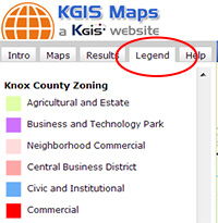
KGIS Maps now has support for legends!  Each map's legend can be toggled on by clicking the "Legend" tab.  The legends are dynamic and will change as one "zooms in and out".  However, it should be noted that some overlays (e.g. TCA Restriction Zones, Soil Types, etc.) may appear slightly different in the legend than they do on the map.

We have also added a link to the City Block Information documents as maintained by the City of Knoxville Technical Services Department.  When you identify a parcel located inside the City Limits,  the "Full Parcel Details" information will contain a "City Block" hyperlink to the PDF document.  Click here to see a screen shot showing the link's location.

Monday, September 23, 2013/Author: Bryan Lynn/Number of views (1303)/Comments (0)/ Article rating: 2.0
Categories: Public

KGIS to conduct User Needs Analysis

to include surveys and interviews


We need your help!

During the next couple of weeks, your various departments will be invited to actively participate in a User Needs Analysis. KGIS has enlisted the help of a consultant to collect an inventory of those GIS features most important and critical to our respective departmental workflows and missions. We therefore encourage your participation in this survey, in the hopes that its results will be of great benefit to KGIS's long-term, strategic planning and new mapping initiatives. For more information, Click Here. 

Tuesday, August 13, 2013/Author: Keith G. Stump/Number of views (98)/Comments (0)/ Article rating: No rating

Multiple Pages link added to top of Results Pane

KGIS Maps

A small enhancement has been made to KGIS Maps to make it easier to step through multiple pages when reviewing the results of a search operation. When reviewing multiple pages of data in the RESULTS pane (along the left hand side of the screen), users now have the option of choosing the "next page" link without having to scroll down. (Each page can list up to 15 different records.) Prior to this change, users needed to "scroll" all the way to the bottom of the results pane, and then select the next page.

Tuesday, August 6, 2013/Author: Keith G. Stump/Number of views (1391)/Comments (0)/ Article rating: No rating

Public Land Inventory has been updated

City and County Owned Land

KGIS has recently updated its inventory list of parcels that are owned by City, County and other public institutions. This list is stored in KGIS's Oracle database, and is therefore accessible to any or our respective ESRI ArcGIS software users. However, one can also access this data via the browser-based KGIS Advanced Maps  application. ...MORE..

Friday, July 26, 2013/Author: Keith G. Stump/Number of views (117)/Comments (0)/ Article rating: No rating
First7891012141516Last

Theme picker