BLynn

EasyDNNNews

KGIS Portal Management Procedures Document

for KGIS Staff

Here is a link to the document that I created that will help us document how best to add news articles to the various sections of the KGIS portal and how to restrict it to the correct audience of users. KGISPortalManagementProcedures.pdf


(This notice itself should only be visible to KGIS staff....If you are NOT a member of the KGIS staff, please contact Keith Stump and let him know that this announcement is visible...because it shouldn't be!)

Friday, April 5, 2013/Author: Keith G. Stump/Number of views (59)/Comments (0)/ Article rating: No rating
Categories: KGIS Staff

2013-2014 Revised School Zones added

Adjusted boundaries for Elementary / Intermediate schools

School Zone SearchThe  School Zone Search and KGIS Maps applications have now been updated to display the recently adopted 2013-2014 elementary and intermediate school zone boundaries for Knox County. The elementary and intermediate zones were adjusted in the western portion of the county to accommodate the new Southwest Elementary School.[Note: High and Middle school zone boundaries are not scheduled to change.] For more information about the zone changes, visit the Knox County Schools website.

Thursday, January 3, 2013/Author: Keith G. Stump/Number of views (1866)/Comments (0)/ Article rating: No rating
Categories: Public

Cartographic changes made to Topographic Map

including Natural Feature label names and Urban Wilderness Trails
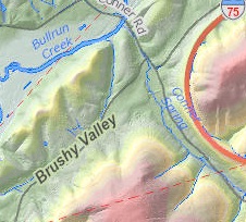
Topographic Map of Knox County (within KGIS Maps) The Topographic Map in KGIS Maps has been re-designed and updated to now include more named  natural landform features, including ridges, streams, gaps, valleys and river bends, along with named points of interests. The urban wilderness trails of S. Knoxville have also been added, along with the recently completed 2010 elevation contours for the eastern half of Knox County (incl. downtown) [Note: the western half reflects 2008 elevation data]. The ability to search for many of these named features is available via the Place Search (located on the top search panel of KGIS Maps).
Tuesday, December 18, 2012/Author: Keith G. Stump/Number of views (1251)/Comments (0)/ Article rating: 4.0
Categories: Public

Welcome to KGIS's re-designed Home Page!!

Links and URLs have also changed

We are in the midst of transitioning our old web site portal to a newer model. As a result, many of the old pages (and URLs) have changed. In particular,  the Owner Card and Property Map & Details reports are now accessed via the Online Reports page. In the meanwhile, if you have trouble locating the information you need, please contact us at 865.215.2641. 
Friday, December 14, 2012/Author: Keith G. Stump/Number of views (1162)/Comments (0)/ Article rating: No rating
Categories: Public

MPC One Year and Sector Plans added to KGIS Maps

under Planning / Zoning tab on left hand side

The MPC One Year Plan and Sector Plans maps have been added to KGIS Maps.To change to the One Year Plan map, click here or click on Maps tab in upper left of KGIS Maps, then expand Planning and Zoning Maps, and then click on the One Year Plan.
To change to the Sector Plan map, click here or click on Maps tab in upper left of KGIS Maps, then expand Planning and Zoning Maps, and then click on the Sector Plan.
Tuesday, November 27, 2012/Author: Keith G. Stump/Number of views (858)/Comments (0)/ Article rating: 2.0
Categories: Public
First1112131416181920Last

Theme picker