Recent Google
Imagery Update Alerts received by KGIS indicate that the aerials for most of Knox County have been updated to what looks to be Fall 2013 vintage. The extents of the new photography are not quite known since it is blended / mosaiced together in a seamless fashion, but the color variations of the tree canopy are indicative of a Fall acquisition. (see image to right)
--------------------------------
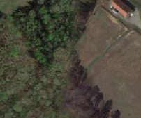
The attached image shows a location off of Hickory Creek Rd in west Knox County (in the Hardin Valley area). When looking closely at the image, one can see the new 2013 Fall imagery on the Right side, but the older Spring 2012 (?) imagery to the left.
Zoom to This Location in Google Maps (and be sure to turn off the 45 degree images in order to view the new Fall 2013 orthos)
Zoom to This Location in KGIS Maps
Google Maps can also be accessed via KGIS Maps and its Launch Tool (located along the top "blue" Toolbar)