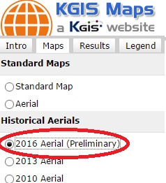
Located under the Historical Aerials group
 A new 2016 Aerial (Preliminary) map theme has been added to KGIS Maps. Since these aerials are preliminary, by-products of the Spring 2016 Knox County Property Assessor project with EagleView - Pictometry , they don't quite meet the product standards of past KGIS aerial products. Therefore, instead of replacing the default Aerial Theme (which is still vintage 2014), the preliminary aerials are located under the Historical Aerials category of Map themes (see image). READ MORE....