BLynn

EasyDNNNews

Last Year's 2014 Tax Roll Values added to KGIS Database

Property Assessor 01-JAN-2014 assessment values

The Property Assessor's last-year final 2014 Tax Roll tables have been imported into KGIS's Oracle database for those ArcGIS users who may want to access those 01-JAN-2014 values.  These attributes... READ MORE
Wednesday, March 5, 2014/Author: Chris Halcomb/Number of views (117)/Comments (0)/ Article rating: 5.0

Results of User Needs Analysis presented to Executive Subcommittee

Submitted by Plangraphics in November 2013

Plangraphics issued a set of eleven primary recommendations to the User Needs Analysis subcommittee in November 2013. The results included an Executive Summary document, a PowerPoint Presentation, and a set of supporting documents that were compiled by Plangraphics as part of its data gathering task. The results of an online survey (conducted via Survey Monkey) were also presented. The  Coordinating Committee's Executive Team plans to share the results of this user needs analysis at the next Policy Board Meeting... READ MORE 
Friday, January 31, 2014/Author: Keith G. Stump/Number of views (6694)/Comments (0)/ Article rating: No rating
Categories: KGIS Depts

Aerial Mission Status: "Wait for the Melt"

Pictometry planes on site and ready for deployment

KGIS has received word from Pictometry, Inc. that the airplanes are on site, and ready to pursue the aerial photography mission on behalf of the County Property Assessor and KGIS. The flight crew delivered the message “Warmer weather head, we’ll wait for the melt.”  The aerial services contract calls for the aerials to be available for viewing by KGIS within 30-60 days from acquisition. Click Here to view some photos of their scouting mission.

Friday, January 31, 2014/Author: Keith G. Stump/Number of views (117)/Comments (0)/ Article rating: No rating
Categories: KGIS Depts

KGIS has switched back to the 2010 Aerials as the default Aerial map theme.

Because of problems caching the 2013 Aerial imagery KGIS has switched back to the 2010 Aerial as the default Aerial map theme. If you want to switch to the 2013 Aerial you can change map theme by clicking on the Maps tab, next click on Historical Aerials drop-down arrow to the right of the word Historical Aerials, then click on the circle to the left of 2013 Aerial. (For more info click here.)

Tuesday, January 14, 2014/Author: Jimmy Brink/Number of views (1083)/Comments (0)/ Article rating: No rating
Categories: PublicKGIS Depts

2010 Census Data in KGIS Advanced Maps

Tract Numbers and Population Labels

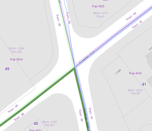
The Census data layers have been updated on the KGIS Advanced Maps website to display the 2010 Census Tracts and population labels. To display the Census map theme click here or click on the Maps tab left of the map, then expand the Other Maps section, next click on the Census Tracts map theme. For more information, Click Here.

Tuesday, December 3, 2013/Author: Jimmy Brink/Number of views (93)/Comments (0)/ Article rating: No rating
First34568101112Last

Theme picker