What's New

What's New or Updated

QC'ing the Contours

New 2' contour data covers all of Knox and KUB areas

TESTING....KGIS has just received a delivery of the 2' contour data covering all of Knox County and the entire KUB service area. The dataset is HUGE! More than 17 gigs in size (as compared with our previous contour dataset size of 5 gigs). And the detail seems to reflect the very high accuracy of the LiDAR data that was flown at a 4 points per meter density back in the spring of 2016. READ MORE...


Monday, May 8, 2017/Author: Keith G. Stump/Number of views (149)/Comments (0)/ Article rating: No rating

City Tax Levy Link is now supported

accessed via KGIS Maps - Full Parcel Details
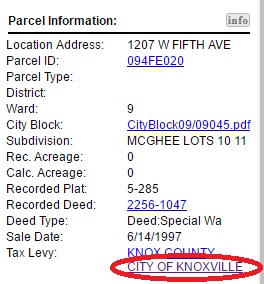
The City of Knoxville Tax Levy Link has been updated to provide quicker, easier access to City Finance's Tax Lookup website. The Tax Levy link can be accessed via the Full Parcel Details section of KGIS Maps. (see image).

Follow these steps to get to the Tax Levy Link in KGIS Maps:

  • Select a parcel via the Parcel Identify tool (located on the blue command bar) or via the Search By tool located at the top of the page.
  • Then, within the Parcel Info bubble, click on the third icon: Get Full Parcel Details 
  • Then, scroll down the Results pane to the hyperlinked text Tax Levy: "CITY OF KNOXVILLE"
Monday, March 13, 2017/Author: Anonym/Number of views (81)/Comments (0)/ Article rating: No rating

Aerials now reflect Spring 2016 flight

KGIS Maps and other web-applications Updated

The Aerial map theme has been updated in KGIS Maps, and in other web-based sites such as City Survey Control, to reflect the recently flown 2016 ortho-photography (acquired from The Atlantic Group LLC). 

Previously, the Aerial theme had reflected spring 2014 vintage photography. To gain access to that original 2014 data, users can click on the 2014 Aerial theme located under the Historical Aerialscategory of Map themes (see image). READ MORE....

Tuesday, October 18, 2016/Author: SuperUser Account/Number of views (192)/Comments (0)/ Article rating: No rating

ArcMap GIS users can now access 2016 Aerials and LiDAR

Accessible via an Image Service and via Shared Folders

ESRI software users of the City, County, KUB and MPC can now access the recently acquired 2016 Aerial Ortho Imagery and the LiDAR datasets hosted on the KGIS System. To access the Image Service, which is called "2016_Knox_County", ArcGIS Users can   READ MORE...

Tuesday, October 18, 2016/Author: SuperUser Account/Number of views (128)/Comments (0)/ Article rating: No rating

Preliminary 2016 Aerial Theme added to KGIS Maps

Located under the Historical Aerials group

A new 2016 Aerial (Preliminary) map theme has been added to KGIS Maps. Since these aerials are preliminary, by-products of the Spring 2016 Knox County Property Assessor project with EagleView - Pictometry , they don't quite meet the product standards of past KGIS aerial products. Therefore, instead of replacing the default Aerial Theme (which is still vintage 2014), the preliminary aerials are located under the Historical Aerials category of Map themes (see image). READ MORE....

Thursday, May 26, 2016/Author: Keith G. Stump/Number of views (507)/Comments (0)/ Article rating: No rating
1234

Theme picker