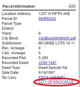
The City of Knoxville Tax Levy Link has been updated to provide quicker, easier access to City Finance's Tax Lookup website. The Tax Levy link can be accessed via the Property Details section of KGIS Maps. (see image).
Follow these steps to get to the Tax Levy Link in KGIS Maps:
- Select a parcel via the Parcel Identify tool (located on the blue command bar) or via the Search By tool located at the top of the page.
- Then, within the Parcel Info bubble, click on the third icon: Get Full Parcel Details
- Then, scroll down the Results pane to the hyperlinked text Tax Levy: "CITY OF KNOXVILLE"