What's New

What's New or Updated

QC'ing the Contours

New 2' contour data covers all of Knox and KUB areas

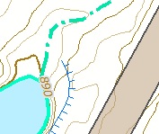
TESTING....KGIS has just received a delivery of the 2' contour data covering all of Knox County and the entire KUB service area. The dataset is HUGE! More than 17 gigs in size (as compared with our previous contour dataset size of 5 gigs). And the detail seems to reflect the very high accuracy of the LiDAR data that was flown at a 4 points per meter density back in the spring of 2016. READ MORE...


Monday, May 8, 2017/Author: Keith G. Stump/Number of views (152)/Comments (0)/ Article rating: No rating

LiDAR Flight Mission has been Completed

As of Tuesday, March 8th, 2016

The Atlantic Group has indicated that its LiDAR flight acquisition, covering all of Knox County and the extended KUB service area, was successfully completed yesterday (Monday March 7th, 2015). READ MORE...

Tuesday, March 8, 2016/Author: Keith G. Stump/Number of views (136)/Comments (0)/ Article rating: No rating

KGIS Receives Final Flight Plans for LiDAR and Aerial Photography Acquisitions

Spring 2016 Aerial Topographic Update

Atlantic delivered the final flight plans for the LiDAR and Aerial photography acquisitions today. As soon as  weather permits, they will fly LiDAR first and then the aerial photography mission will follow within 2-3 weeks. Atlantic was scheduled to be here on February 9th for a project kick off meeting, but we had to reschedule due to weather. The Kickoff Meeting of the Spring 2016 Aerial Topographic Update project has been re-scheduled for Tuesday, Feb 23rd 2016. click here to see the flight paths.

Tuesday, February 16, 2016/Author: Chris Halcomb/Number of views (86)/Comments (0)/ Article rating: No rating

KGIS issues RFQ for Aerial, LiDAR and Topographic Update

via Knox County Purchasing

On behalf of KGIS, the Purchasing Division of Knox County TN has posted a Request for Qualifications (RFQ) for the capture, processing, and / or update of digital aerial orthophotography, LiDAR, hydrography, breaklines, spot elevations and contours for all of Knox County and optionally the KUB extended service area. For more information, and inquiries, visit the Solicitations page of the Knox County Purchasing website.

Tuesday, September 8, 2015/Author: Keith G. Stump/Number of views (612)/Comments (0)/ Article rating: No rating

Topographic Compare Tool provides visual look at Contour products

LiDAR derived contours vs KGIS's Traditional contour product

The KGIS Staff has created a web-based Topographic Contour Comparison Tool that will provide departments with a visual look at the different types, and vintages, of contour products being considered as a replacement and/or update to KGIS's aging Topographic Map. (now approaching 8 years old for the western half of Knox County). LiDAR data is a key ingredient to the Landbase Update program of KGIS, having been used for both the 2003 topographic map update (by Merrick) and the 2007-2010 update (by Sanborn). READ MORE

Tuesday, May 19, 2015/Author: Keith G. Stump/Number of views (98)/Comments (0)/ Article rating: No rating
12

Theme picker