 ESRI software users of the City, County, KUB and MPC can now access the recently acquired 2016 Aerial Ortho Imagery and theLiDAR datasets hosted on the KGIS System. To access the Image Service, which is called "2016_Knox_County", ArcGIS Users can
------------------------------
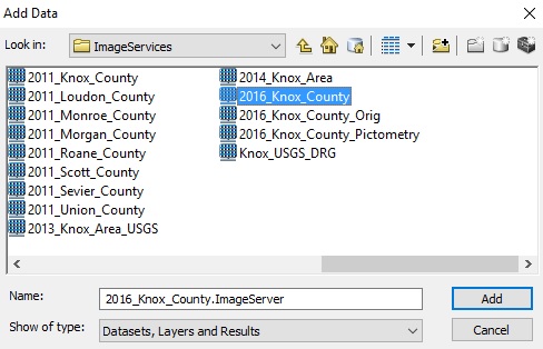
issue the following command: Add Data...then, navigate to the following folder: GIS Servers...arcgis on www.kgis.org (user)...ImageServices. (see image). Then select the 2016_Knox_County service. (see image)
The image service covers Knox County along with service area of KUB extending outside of Knox County.
The newly acquired LiDAR datasets can be found on the shared KGIS disk drive KGISCCPRFS1, in the Lidar Data...2016 folder.(note: the LiDAR datasets will be re-processed later this Fall 2016 with updated hydrographic and building classifications derived from the Phase II mapping contract with The Atlantic Group LLC.)
If users have trouble accessing these datasets, please contact KGIS's system manager John Edwards at 215-3130 or KGIS's database administrator Chris Halcomb at 215-3906.
Users should note that the 2016 aerials are also viewable via most of KGIS's publicly accessible, and restricted / internal, mapping websites, including KGIS Advanced Maps, County Storm Maps, etc.