 The KGIS Staff has created a web-based Topographic Contour Comparison Tool that will provide departments with a visual look at the different types, and vintages, of contour products being considered as a replacement and/or update to KGIS's aging Topographic Map. (now approaching 8 years old for the western half of Knox County). LiDAR data is a key ingredient to the Landbase Update program of KGIS, having been used for both the 2003 topographic map update (by Merrick) and the 2007-2010 update (by Sanborn).
----------------------------------
One of the great things about LiDAR is that it can be used to create a very accurate 3-d view of the terrain, including a robust set of contours. However, the contours derived solely from LiDAR will NOT, in an of themselves, be an exact replacement to the traditional Topographic Map product to which KGIS users have become accustomed over the past 25 years. Additional data classification, mapping and cartographic processing tasks must be performed (as a supplement to the LiDAR data) in order to arrive at the traditional, cartographic-correct "topo" map.
So, understanding the limitations of the LiDAR-derived products is important. Hopefully this Comparison tool (currently in BETA form) will provide a visual means of seeing some of those differences.
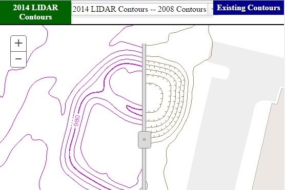
The current format of the application provides four different views of a sample area located in the newly constructed Powell Rd (Powell Bypass) project in the northwest quadrant of the County. The LiDAR Contours shown in the app were generated by KGIS staff from the 2014 Pictometry-led LiDAR mission (which was rejected due to several issues with the data, including large gaps of coverage and missing / incorrect intensity values). Nevertheless, the ground-level information in the LiDAR dataset is deemed by KGIS to be good enough for demonstration purposes.
The four different views are:
- A comparison between 2014 LiDAR-derived contours vs. KGIS's 2008 Topographic Contour product
- A view of the 2008 Topo Contours shown over the 2014 Aerial Ortho-photography
- A comparison between the 2014 Aerial Ortho-photos and the 2008 Aerial Ortho-photos
- A view of the 2014 LiDAR-derived contours shown over the 2014 Aerial Ortho-photography
Since the hydrographic (water) and spot elevation data has not been updated since 2008, KGIS staff did not use the those features as a variable when generating the 2014 LiDAR-derived contours. (Mixing and matching data from two different timeframes would result in an inaccurate representation of terrain). This is why the stream and spot elevation features do not align with the new 2014 LiDAR-derived contours, and explains why the new 2014 contours do not cartographically match with those items.
For more information about the Landbase Update program, including the Strategic Plan document, visit the Projects....Landbase page on this website.