The 2013 Aerial Imagery from USGS has been added to KGIS Maps Aerial map theme. To view click on the Maps tab left of the map, next click on the Aerial map theme under Standard Map. For metadata on the 2013 USGS Aerial Imagery click here.
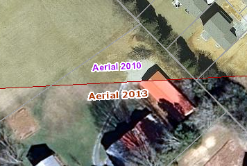
It should be noted, however, that the newly acquired 2013 aerial imagery does not cover all of Knox County, especially along the northern and eastern edges. Therefore, the new 2013 aerials have been blended (or “cached”) together with the 2010 aerials to make for a seamless coverage, and the boundary has been added to the map to indicate where the two different aerials meet (see image to the right). The 2013 Aerial does cover some of Anderson, Blount, Loudon, and Sevier Counties. The USGS 2013 Aerial Images are not as precise as the previous 2010 Aerials, around a 1 foot resolution, compared to 6 inch resolution for the 2010 Aerials. If you would like to see the older 2010 Aerial Imagery click here or change the map theme to the 2010 Aerial under Historical Aerials. The rest of the gray imagery is from older imagery of the regional counties around Knox County.