MPC’s Proposed Hillside Protection Maps added to KGIS
Author: Bryan Lynn/Monday, March 7, 2011/Categories: Public
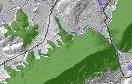 MPC has added the proposed Hillside and Ridgetop Protection Areas to each of KGIS's interactive mapping websites: KnoxNetWhere , KGIS Lite (which has now been replaced by KGIS Maps) and MPC Case Mapping. This map will enable residents to determine whether all or portions of their property falls within the Hillside Protection Area through searches by address, parcel ID number or owner name. Read More...